When Scotland was on the Equator
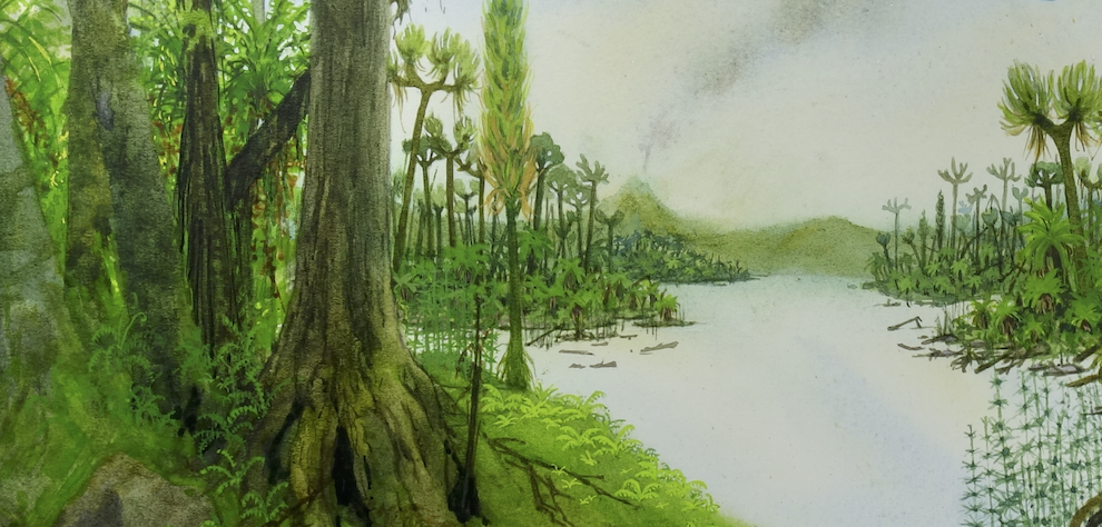
Imagine standing in West Lothian 340 million years ago. Lothian was very different then, so let’s try to paint a word picture of what our wee bit of Scotland was like then. Scotland wasn’t in the northern hemisphere where we are today. We lay around the equator so it would have been quite hot and humid. To the north and west lay the Caledonian Mountains stretching from Scandinavia, across Scotland to the Appalachians – the Atlantic Ocean hadn’t opened up yet. To the south and east lay a tropical sea teeming with life.
A Precarious Coastal Plain
The Lothians was in that place twixt land and sea, on a wide coastal plain occasionally inundated by the sea as sea-level rose and fell. The area had been subjected to volcanic activity with lavas emanating from Arthur’s Seat, Castle rock and other volcanic centres. It was in this relatively flat coastal setting that the oil shales of the Lothians formed.
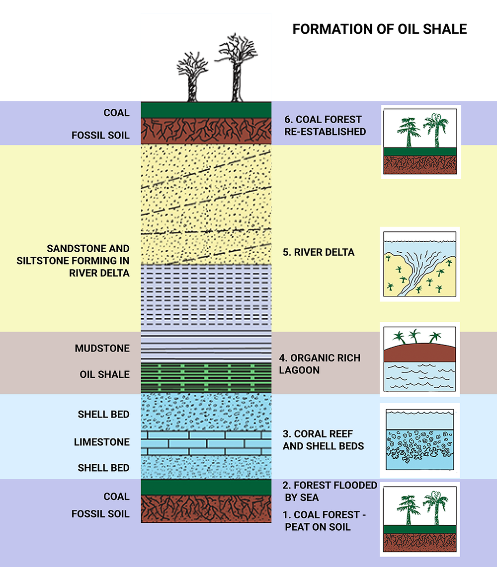
The Carboniferous period was characterised by rapidly changing environments, leading to alternating layers of rock or strata. These are often in regular patterns repeating the same sequence of rocks.
Lagoons with organic rich muds gave rise to the Oil Shales of West Lothian.
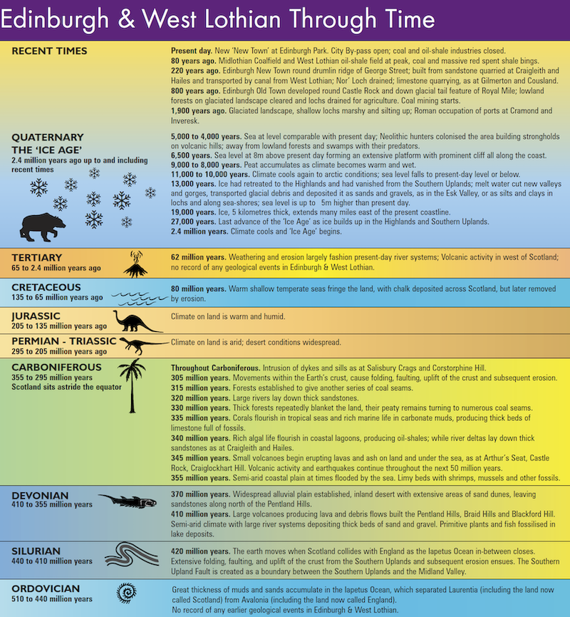
Image Source: Adapted from Edinburgh & West Lothian: A Landscape Fashioned by Geology, Scottish Natural Heritage/British Geological Survey, 2003
Lake Cadell
The shallow coastal plain was susceptible to flooding by the sea and it created a body of shallow water, Lake Cadell. The lake was often cut off from the sea, and fine-grained sediment built up. So we can find sediments deposited in a freshwater lake but also some formed in brackish lagoons and also marine deposits when the sea flooded the area. When the lake was cut off from the sea it would lack the mixing power of ocean waves. The waters of the lake became layered, oxygenated near the surface and around the edges but becoming stagnant at depth. If we use that saying by James Hutton , the Father of Modern Geology, that “the present is the key to the past” then we must imagine what the lagoon would be like and the creatures that might live there.
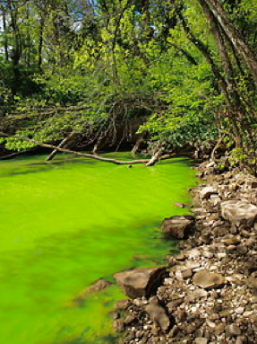
At the heart of the lake
Around the edges of the lake, there was fresh or slightly salty water. In the warm conditions the edge of the lake dried up forming mud cracks in the sediment. The organisms living here were shell fish, some like modern mussels, that can tolerate differences in salinity. Algae will flourish as there are few organisms to eat it. Further into the lake surface waters would support some fish and algal blooms flourished. In the deeper water conditions were stagnant and all the organic matter sank to the bottom and built up in deposits. It is here in the heart of the lake that the organic matter was incorporated into the muds to produce what we now call the oil shale.
Image Source: Wikimedia Commons
From Mud to Shale
These deposits changed through time to produce the oil shale mined by James “Paraffin” Young. These changes happened as the sediments with their organic content were buried and subjected to increased pressure. But not quite the increase in temperature and pressure required to produce oil and gas as we have in the North Sea basins.
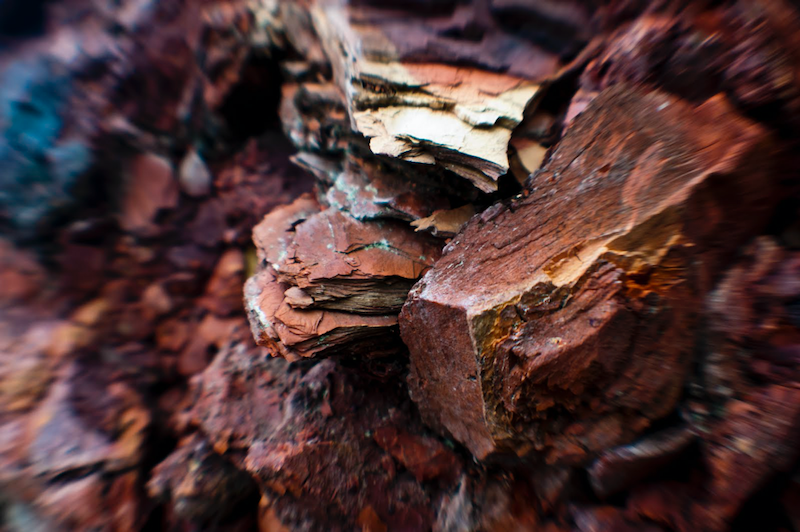
Image Source: Jon Eland
From Shale to Oil
The drive of the industrial revolution created a demand for fuel and lubricants. James Young’s method helped to satisfy that need. The oil shale seams were mined and fed into retorts where the temperature was increased to release the hydrocarbons trapped in the shale. Paraffin and other hydrocarbon products were produced and the spent material deposited in the red burnt shale bings that characterise the landscape of West Lothian.
Clues to the Past
East Kirkton Quarry, near Bathgate in East Lothian has yielded some fascinating fossils including a small creature thought to be one of the world’s earliest reptiles. The fossil is commonly known as “Lizzie” but also with the much grander Latin name of “Westlothiana lizziae”. The fossils from this area, have helped us understand the history of life on Earth when creatures crawled from the sea to inhabit the land around 340 million years ago.
Geological Timeline
With thanks to Prof Stuart K Monro OBE, FRSE Honorary Professor, University of Edinburgh for the text and advice for this page.